the Creative Commons Attribution 4.0 License.
the Creative Commons Attribution 4.0 License.
 | 04 Jun 2018
A forensic re-analysis of one of the deadliest European tornadoes
Thomas M. E. Schreiner
Tomáš Púčik
Extremely rare events with high potential impact, such as violent tornadoes, are of strong interest for climatology and risk assessment. In order to obtain more knowledge about the most extreme events, it is vital to study historical cases. The purpose of this paper is twofold: (1) to demonstrate how a windstorm catastrophe that happened 100 years ago, such as the Wiener Neustadt, Lower Austria, tornado on 10 July 1916, can be successfully re-analyzed using a forensic approach, and (2) to propose a repeatable working method for assessing damage and reconstructing the path and magnitude of local windstorm and tornado cases with sufficient historical sources. Based on the results of the forensic re-analyses, a chronology of the tornado impact is presented, followed by a description of the key tornado characteristics: a maximum intensity rating of F4, a damage path length of 20 km and a maximum visible tornado diameter of 1 km. Compared to a historical scientific study published soon after the event, additional new findings are presented, namely the existence of two predecessor tornadoes and a higher number of fatalities: at least 34 instead of 32. While the storm-scale meteorology could not be reconstructed, rich damage data sources for the urban area of Wiener Neustadt facilitated a detailed analysis of damage tracks and wind intensities within the tornado. The authors postulate the requirement for an International Fujita Scale to rate tornadoes globally in a consistent way, based on comparable damage indicators.
- Article
(6266 KB) -
Supplement
(57 KB) - BibTeX
- EndNote


Prior research on historical tornadoes mainly focused on climatological analyses of pre-analyzed cases or pre-existent datasets: Snitkovskii (1987) for Russia, Dessens and Snow (1989) for France, Holzer (2001) for Austria, Brázdil et al. (2012) for the Czech Republic, Brown and Rowe (2012) and Brown et al. (2013a, b) for Great Britain, or Taszarek and Gromadzki (2017) for Poland. Gayà (2007) discussed the 1886 Madrid tornado, van der Schrier and Groenland (2017) the extreme wind damage of 1 August 1674 from northern France to northern Holland. In the United States, Johns et al. (2013) investigated the damage path of the catastrophic 1925 Tri-state Tornado, but the question of damage rating for historical events remained open, as these authors concentrated on “damage points”. Despite noting that 92.5 % of their analyzed damage points were rated with intensities, their respective data and methodology were not presented, and their paper ultimately focused on track continuity rather than on single intensities.
In order to classify the magnitude of a specific historical tornado, a detailed forensic re-analysis is needed. In the case of the 1916 Wiener Neustadt tornado, both written reports and a few damage photographs of the severe windstorm event were already known prior to this study. In 1917, a detailed scientific paper (Dörr, 1917) documented the event and discussed its meteorological characteristics. This paper included information retrieved from eyewitnesses and a city map of the buildings damaged or destroyed. While contemporary knowledge did not allow for estimations of the maximum intensity of a windstorm or tornado based on damage, this is now feasible due to significant advances in the areas of severe convective storms and tornadoes, building aerodynamics, and structural analysis.
The assessment of extreme events is important for sound statistics of those rare phenomena (Letzmann, 1939), and emerging trans-national tornado climatologies in Europe (Groenemeijer and Kühne, 2014) seek to enlarge the climatological time periods. The European Severe Weather Database (ESWD, Dotzek et al., 2009) serves as the main source for historical tornado data in Europe (Groenemeijer at al., 2017). All ESWD reports must pass basic quality and source checks; reports that do not meet these criteria are discarded from the database. Recent studies by Antonescu et al. (2016) and Antonescu et al. (2017) discussed the present availability of national and regional tornado climatologies in Europe and highlighted the underestimated risk of these hazards. Antonescu et al. (2018) used the tornado outbreak on 24 and 25 June 1967 in western Europe to create scenarios in the present, yielding 170 to 1696 fatalities. This example demonstrates that local tornado intensity distributions are not only important for climatology and risk assessment, but also needed to serve as exercise scenarios for the purposes of civil protection.
As a consequence the following research aims arise:
- a.
What kind of original sources can be found?
- b.
How strong was the event on nowadays tornado damage rating scale?
- c.
Is it ultimately possible to draw a coherent meteorological picture of the entire event?
- d.
Can a repeatable working method for damage assessment and rating of historical events be developed?
The purpose of this paper is twofold:
-
to show that a successful forensic re-analysis of a historical tornado case is possible, if sufficient sources can be found;
-
to propose a repeatable working method for damage assessment, path and magnitude reconstruction of historical local windstorm and tornado cases.
The study methodology consists of the following steps that are described in greater detail below:
-
retrieval of historical sources and their preparation
-
geo-referencing of source information
-
application of the damage indicator vs. degree of damage approach (DI–DoD approach) to the historical material
-
aggregation of singular data points into damaged objects
-
data mapping.
2.1 Retrieval of historical sources and their preparation
Damage assessment of a recent tornado typically starts with a careful local inspection and site survey of the damaged area. Damage needs to be assessed as quickly as possible after the event occurs, as clean-up efforts are a major concern for this task. For historical cases, a real-time damage assessment is not possible. Instead, a thorough search for original sources and in-depth analyses of the event needs to be performed, followed by a historicocritical evaluation of the image sources and text sources found.
In total, 11 archives were browsed over a period of about two years, most of them non-digital paper archives from municipal record offices, local museums, and the Austrian National State and War Archive. The material found was sorted, classified and digitized. Original photographs of storm damage were scanned and saved in high resolution. All times stated in this paper originate from historical text sources and refer to local time.
2.2 Geo-referencing of source information
The goal is to rate damaged objects and to locate them. For damage photographs lacking meta-information the geographic position is not evident at first and needs to be determined by other sources, where possible. Written damage reports can also contain specific details with geographical references. Photographs from different perspectives can reveal different construction and damage details. Physical interpretations of the damage and the sturdiness of the damaged object may vary depending on the point of view, time of image taken, light conditions, and many other factors. In some cases, more than one damage photograph is available for a specific object of interest. Careful geo-referencing of objects in a photograph is necessary in order to allow for the spatial grouping of such photographs. This requires a forensic approach to determine the position of the photographer and their viewing orientation. Some objects in the photographs may not qualify for a damage rating if they are not well-resolved, too small, too far away or if the sturdiness of the object cannot be determined. There is only enough information available to assign a damage rating for some objects in certain photographs. Many such objects can be classified as “damaged” (helping to determine the width of the damage path), but without a specific rating.
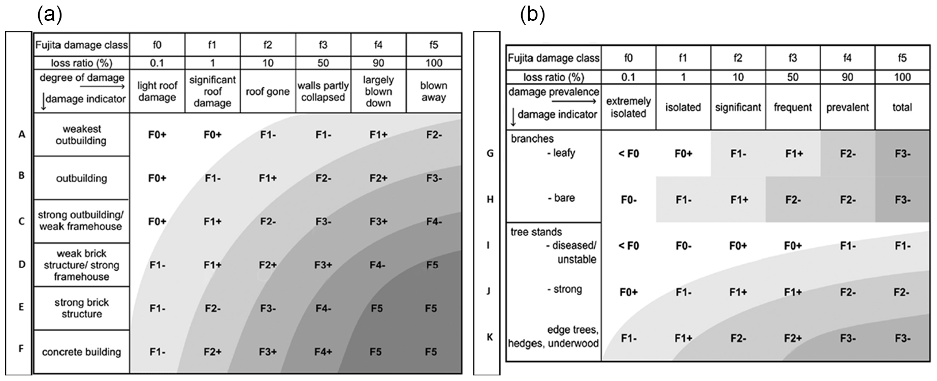
Figure 1Damage rating matrices for buildings (a) and vegetation (b), adapted from Feuerstein et al. (2011).
The typical precision of achieved object localization is on the order of distinguishing street numbers, i.e., one house from its neighboring house, or between meters and decameters. In some cases, historical street maps were necessary to perform this geo-referencing task, especially where the building structures of whole blocks were modified and neighborhoods rebuilt over time.
2.3 Review of scales and application of the DI–DoD approach to the historical material
The European Severe Storms Laboratory (ESSL) assigns windstorm damage ratings using a damage indicator (DI) vs. degree of damage (DoD) approach. The results are then mapped on the Fujita Scale (Fujita, 1971). Fujita originally defined his intensity scale for a strong US frame house, but later in a memoir refined the method to derive an F-scale intensity rating by introducing a conversion table for six generic building types: weak outbuilding, strong outbuilding, weak frame house, strong frame house, brick structure and concrete building (Fujita and Merriam, 1992). The revised method converts a damage f-scale to a wind speed F-scale score by adding or subtracting pre-defined full scale steps, depending on whether the building in question was stronger or weaker than the strong US frame house. Fujita notes in his memoir on page 31 that “For determining the F scale, we have to estimate the f-scale damage of any structure with damage. Then we select the F scale as a combination of f scales and structure types.”
Based on the Fujita conversion table from the f-scale to the F-scale, Feuerstein et al. (2011) proposed a decision matrix for damage assessments that already includes the results of the conversion step and refines the outcomes to the lower or upper half of each original step. Feuerstein et al. (2011) also designed a vegetation decision matrix following the same approach as the building type matrix, without including cornfield damage (Fig. 1). Vegetation damage was also taken into account for the present case. Fujita already included vegetation damage for the rating – in the original version of 1971 in a broad descriptive form, and on page 33 in the 1992 memoir in the form of a collection of cornfield damage pictures for every single F-scale step from F0 to F5, called “F-scale damage chart” (parallel to one for the strong US frame house).
The DI–DoD method was being used by the EF-scale (EF-Scale document, 2006) in the United States and other countries, but with more specific DIs and different degrees of damage. Outside of the United States, many DIs cannot be used because of specific building codes and practices that prohibit their existence. In addition, DIs of the EF-scale are not defined to be used for historical building types. Therefore, the EF-scale is not applicable for the re-analyses of historical European tornado cases (Doswell et al., 2008), and this study instead employed the decision matrices from Feuerstein et al. (2011).
From each damage description or photograph, those objects with usable information are classified. Contained information needs to be clear enough to be utilized for the DI and DoD approach. First, the most appropriate damage indicator is chosen, and then the degree of damage is determined. Only the descriptive “damage prevalence” (see Fig. 1) from the Feuerstein et al. (2011) matrix is used for this assignment; the economic “loss ratio” is excluded. Damage prevalence here refers to a subjective class of destruction. For each data point such an approach was taken. The outcome is a “first guess”. If several damaged objects were visible on one image, each object was rated independently. To make the outcome transparent for each usable damaged object, not only the final rating (for example: “F3−”) was documented, but also the underlying DI in letter abbreviation, for example, “C” for a strong outbuilding or weak frame house) and the determined DoD number from the f-scale damage class (e.g., “f3” for “walls partly collapsed”). The DI–DoD pair alone already contains all information, but as expressions in the Fujita Scale were common worldwide in the past and are still used in some parts of the world, the outcome is also presented in the refined F-classes in order to allow for direct comparison with other datasets.
2.4 Aggregation of singular data points into damaged objects
Next, a database of DI–DoD pairs from different information or image sources needs to be condensed into a database of damaged objects. For each object, only one damage rating shall remain, which is necessary in case of the availability of more than one singular data point. Additional hints can be used for the object rating, hints that may not have been present in the single piece of information in the first step, as a better view on the sturdiness of an object or its construction design and materials. The more singular data points (“first guesses”) are available, the more confident is the object rating. The outcome of this procedure is one aggregated rating for each damaged object.
2.5 Data mapping
After consolidating the damage information, the geographical positions of the damaged objects are plotted on a map. This step is necessary to perform a plausibility check of local inhomogeneities along the damage path. Given the small-scale phenomenon of tornadoes, temporal and spatial changes in wind speed can occur rather abruptly. Given this physical nature, it is important to avoid excessive spatial smoothing of tornado damage. This iteration step shall mainly lead to another critical review of single suspect object ratings, not to a general smoothing. If no additional reason was found to change the original damage rating (e.g., a weakness in the construction of a wall that was not recognized in earlier steps), the original damage rating is kept.
After this plausibility check, the final object ratings are fixed and can be ultimately plotted and used for further analyses. In the case of the 1916 Wiener Neustadt tornado, the density of final ratings was high within the urban area of the damage track, while only single data points could be fixed for rural areas along the track to the west and east of Wiener Neustadt. In addition to the damage rating, information on tree-fall patterns, directional bending of objects and falling directions of walls was documented, where available. It is important to retain all final data points and their DI–DoD pairs for potential future needs, not only a single final maximum rating for the whole event.
Based on the contemporary findings of Dörr (1917) and four eyewitness reports (Karl Bauer from the village of Lichtenwörth, Alfons Friedel from the village of Wöllersdorf, Leopold Schmidt in a train from Leobersdorf to Wiener Neustadt, and a Lieutenant of the Austro-Hungarian army on a train from Wiener Neustadt to Vienna) it is clear that the nature of the wind event was tornadic. Observational descriptions included the depiction of a funnel or column and compared the visible notion of the tornado with smoke-like appearance. The German terms for a “whirlwind” were used repeatedly in contemporary texts. Furthermore, the long but narrow track is a strong indicator for a tornado, as is the specific falling direction of objects relative to their proximity to the estimated center of the storm.
While exact time readings of the beginning and end of the event do not exist, the maximum time range for the catastrophe can be narrowed down to between 17:30 and 18:00. Event duration of only 10 min mentioned by Dörr (1917), without quoting reference times, seems inappropriately short. In this work for a track length of about 1 km a time span of already 4 min was quoted, leading to inconsistent estimates for the total track.
An early anemograph recorded a wind speed in excess of 40 m s−1 on the western airfield of Wiener Neustadt over duration of 3 min (Dörr, 1917). Given a lack of precise time readings, the translational speed of the tornado cannot be estimated with confidence. Two independent eyewitness reports exist for the time immediately before the main tornado struck the town of Wiener Neustadt. Both reports are credible and consistent with documented damage, but actually describe two different tornadoes. These two tornadoes are hereafter referred to as “predecessor tornadoes”. While Dörr (1917) only mentions a western predecessor tornado on the western part of the main tornado track, another eyewitness report (WNN, 1916) only describes the existence of a northern predecessor tornado. This discrepancy leads to the scenarios that in the area of the western airfield, either two predecessor tornadoes merged into the main tornado, or one of these tornadoes became dominant while the other dissipated. Without knowing precise time readings, the following chronological order can be reconstructed.
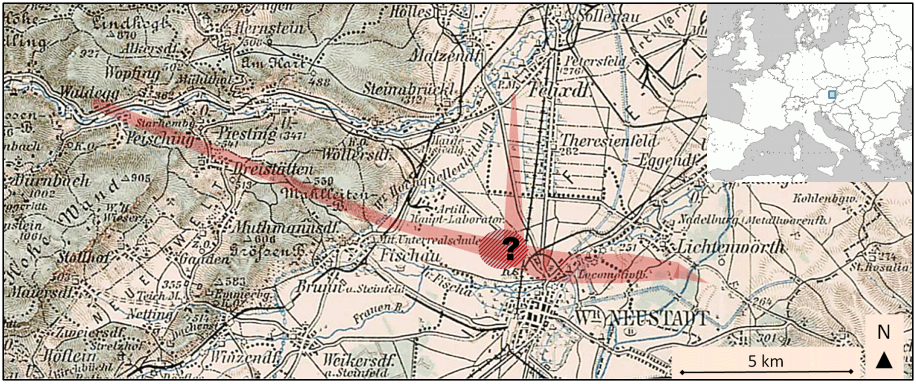
Figure 2Map of tornado damage tracks (red shadings) in the Wiener Neustadt area. The hatched area with the question mark denotes the airfield west of town, where the exact genesis of the main tornado is unknown. The map used as a based was the “Generalkarte von Mitteleuropa des k.u.k. Militärgeographischen Instituts Wien, Blatt 34∘48∘Wien” of 1893.
3.1 Western predecessor and main tornado
The first damages were documented in the village of Peisching (Dörr, 1917), located in the Piesting valley, 15 km west–northwest of Wiener Neustadt (Fig. 2). The tornado was reported to have formed on a slope to the west of the village, while in Peisching roofs were damaged, and beyond Peisching a continuous visible damage track extended to the Leitha River east of Wiener Neustadt. In the northern part of village Dreistetten, a few houses were severely damaged, and the first severe injury is evident (Herbert Karl, personal communication, 2017; Anton Schramböck, personal communication, 2017). A young farmer, who was at home on furlough from World War I, sustained a severe leg injury after being picked up by the tornado a few meters in height and thrown back to the ground.
The further track over the hills of the Mahlleitenberg was marked by massive forest damage. On the eastern slope, the tornado descended 200 m in elevation to the Steinfeld plain in the southernmost part of the Vienna basin within only about 2 km of horizontal distance, and continued towards the western airfield of Wiener Neustadt. The width of the damage path is unknown up to this point, and no detailed assessment of the forest damage is recorded. Per local personal communication (Herbert Karl, personal communication, 2017; Anton Schramböck, personal communication, 2017), there was no continuous track through this large forest area. However, multiple patches of forest were severely damaged along the imaginary line between the tornado damage in Dreistetten and the appearance of the tornado west of Wiener Neustadt, for example, at a place called “Fiedelwiese”. Several wooden rafter beams from a house in Dreistetten ( “Tilt'sche Villa”, Haltergasse 93) were carried by the tornado over a distance of about 3 km into a forest clearing meadow east of Dreistetten (called “Zwara-Wiesn” or “Hinterwiesn”).
The main tornado entered the urban area of Wiener Neustadt just after passing the major railway lines between the cities of Vienna and Graz. Airfield staff reported a noticeable shift in the tornado's track over the airfield from east–southeast to southeast. This track shift could be an indicator of the interaction between the western and the northern predecessor tornado. Unfortunately, the northern tornado was not discernible to the airfield staff, possibly due to visual obstruction by rain shafts, lighting conditions, or size differences.
After passing the railway tracks, the damage path is clearly verifiable because of a high density of damaged objects. Over the northern section of Wiener Neustadt, called Josefstadt, the tornado track shifted from southeast to east, and after the main impact to the old locomotive factory, turned slightly east–northeast. After crossing the northern parts of Wiener Neustadt, the tornado moved over open fields and dissipated soon after crossing the Leitha River 5 km to the east of town.
3.2 Probable northern predecessor tornado
The eyewitness report of Professor Leopold Schmidt (WNN, 1916), who traveled at the time of the tornado event in a train to Wiener Neustadt, further supports the existence of a northern predecessor tornado. At 17:28, Schmidt departed in the village of Leobersdorf, located 13 km north of Wiener Neustadt, and shortly thereafter observed an intense thunderstorm over the Triesting valley. About 2 km west of the village Felixdorf, Schmidt observed a “small whirlwind” that moved with similar speed and direction (southward) as the train. Close to Wiener Neustadt, the tornado's size and translational speed both increased. Dark farmland soil colored the whirlwind column deeply black with a distinct outer boundary. The large funnel moved towards the airfield hangars.
Interestingly, this trustworthy eyewitness report, although published soon after the event, was not mentioned by Dörr (1917). Independent of the findings of the eyewitness reports, the analyses of the damages reveal that two objects, well north of the western predecessor tornado, were indeed heavily damaged. It is likely that both predecessor tornadoes co-existed for at least several minutes and either merged or approached each other in the area of the airfield in a very narrow time span. These two predecessor tornadoes approached each other in an angle of about 70∘.
3.3 Main tornado impact in town and dissipation
Over the Josefstadt neighborhood, a maximum intensity in the upper F2 range of the Fujita Scale was reached, while the damage width of F0 measured about 400 m. An eyewitness reported a visible tornado diameter of up to 1000 m (WNN, 1916). Further east, in the vicinity of the old locomotive factory, the maximum intensity reached F4 (Figs. 3–5). The width of the damage track at this most devastated place measures about 600 m (Fig. 6).
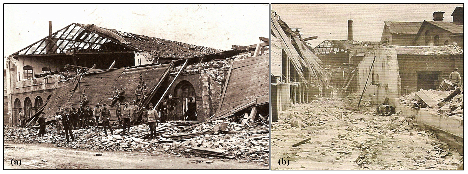
Figure 3Details of the old locomotive factory. (a) Inner ceiling flipped outside, in the foreground the whole upper floor with massive brick walls has collapsed (similar as the building parts that are still visible in the background). (b) Former indoor part of the same building with destruction of up to 1 m thick walls down to the ground level. Source: Industrieviertelmuseum Wiener Neustadt.
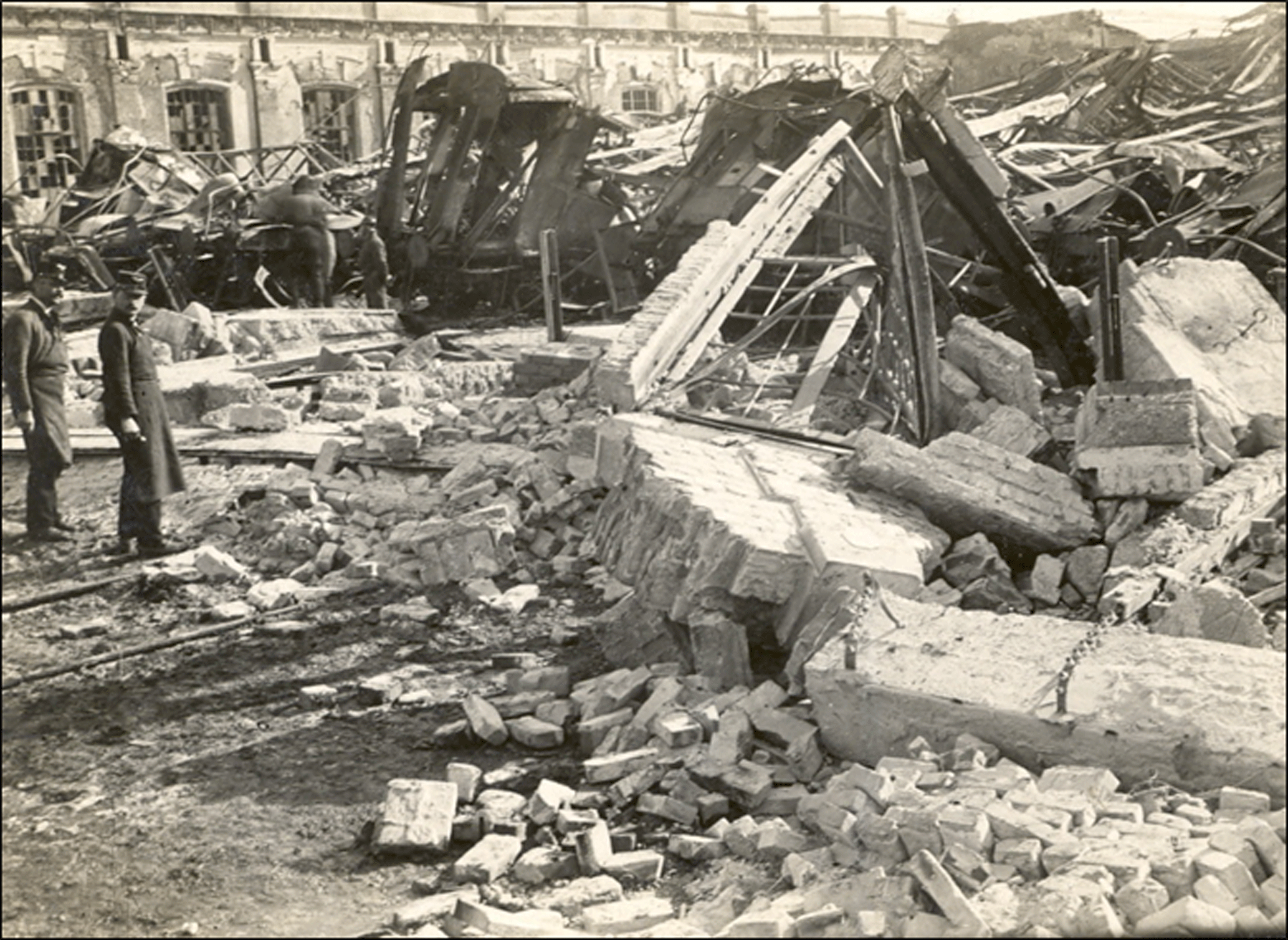
Figure 4F4 destruction on the plot of the old locomotive factory. Photo taken from a private archive in Wiener Neustadt.
As illustrated by the aerial photograph (Fig. 5), the degree of damage varies substantially within extremely small distances, from nearly untouched to total destruction. The spatial pattern of damage substantiates a statement by Fujita and Merriam (1992): “These examples show that tornado winds are highly variable within a short distance both in wind direction and speed, necessitating the use of all types of structures in mapping the F-scale wind pattern.”
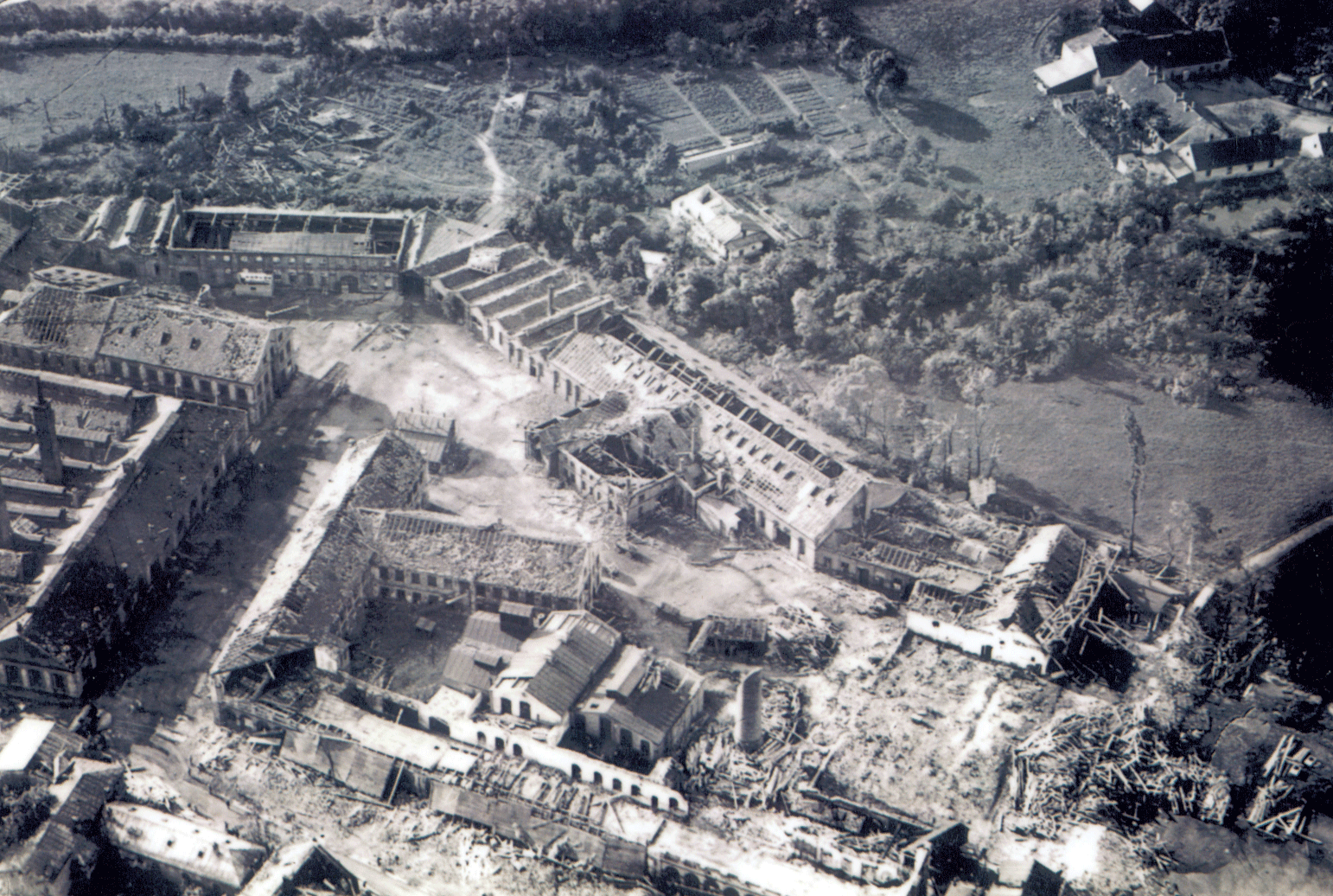
Figure 5Aerial view of parts of the most damaged old locomotive factory. The area in the lower right quarter of the photo suffered the highest levels of destruction. Source: Industrieviertelmuseum Wiener Neustadt.
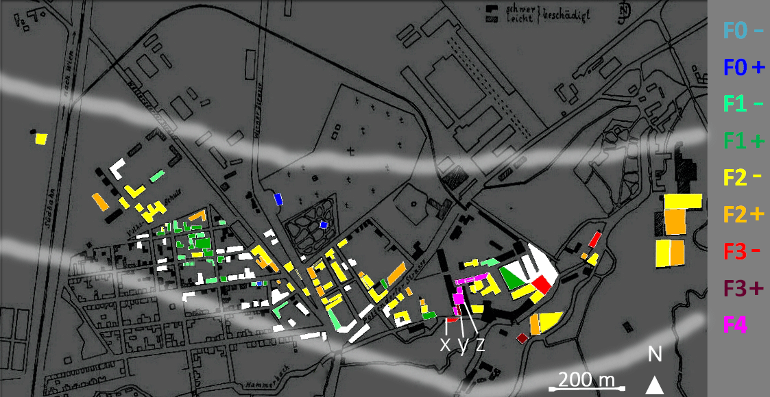
Figure 6Damage map of urban Wiener Neustadt area. Colored shading represents new findings with corresponding scale values given to the right. White filling means that damage was seen on imagery, but an intensity rating was not possible. Soft white boundaries mark southern and northern edges of damages (drawn with manual interpolation). Background map: historic city map (Dörr, 1917). Buildings shaded in dark grey have shown minor damage (leicht beschädigt), buildings shaded in black have shown major damage (schwer beschädigt) in the historical damage survey.
The main justification for the F4 rating in the most devastated area is the fact that several brick walls of about 1 m thickness belonging to the old locomotive factory collapsed. The ceiling between the ground floor and the first upper floor of this building was supported by steel beams, leading to an even more robust sturdiness. A large piece of this floor was flipped outside the exterior walls. An aggressive rating could have classified the DoD as “largely blown down” for important parts of the factory in an area of about 50 m of diameter, which would have resulted in a final F5 rating. Given the uncertainties in the state of conservation of the building and the unknown building structure before the event, the more conservative “walls partly collapsed” DoD was chosen, resulting in the final F4 rating. A neighboring building also experienced the collapse of very thick brick walls, resulting in another F4 rating.
Further east, at the Daimler factory, the maximum intensity decreased to the upper F2 range, and the damage width decreased to 400 m. After leaving Wiener Neustadt, the tornado passed over grassland and crops, eventually reaching the Leitha River and its surrounding forest to the south of the village Lichtenwörth, measuring only 80 m in diameter. Here, the last trees were downed and the tornado dissipated soon after.
4.1 Facts and figures
- a.
The manual search in the different archives unveiled more than 100 damage photographs of the tornado event. In total, 180 single damage sources were found.
- b.
Two predecessor tornadoes existed shortly before the main tornado struck Wiener Neustadt.
- c.
The maximum intensity rating of F4 is supported by the collapse of thick brick walls of two neighboring buildings. The heaviest damage was found in the old locomotive factory, where brick walls of about 1 m thickness were leveled. The small number of objects with such damage intensity is a limitation of the reliability of the maximum rating.
- d.
The tornado path, including the western predecessor tornado, had a length of 20 km.
- e.
The maximum width of the F0 damage was 600 m and the visible diameter was estimated to be 1 km.
- f.
The area under the influence of F2 winds or greater comprised 20 ha within the city of Wiener Neustadt, whereas the area under influence of F0 winds measured 81.5 ha in the urban area. More than 100 houses were affected in the town.
- g.
The final number of fatalities within the urban area of Wiener Neustadt was at least 34. Even higher numbers, reported in some newspapers in Vienna, are referred to as being anecdotal already in contemporary sources.
As can be seen from the city map detail with the historical building structures (Fig. 6), the damage path is widest in the region of the highest intensity ratings (F4, purple). Some abrupt changes in intensity close to the worst damage (F2 damage adjacent to F4 damage) may be attributed to the fact that in the affected industrial zone some sturdy structures largely survived and may have provided shelter to neighboring objects (see also aerial photo in Fig. 5). In the damaged area with smaller houses to the west the pattern seems to be much smoother.
An example for a DI–DoD pair from the region of highest interest is the old locomotive factory, located at 47.82861∘ N, 16.251412∘ E (Fig. 3b): the photographer documented in the foreground the (pre-event) indoor part of the factory. Remaining foundations of a largely destroyed massive brick wall are visible on the right side. The remaining building parts on the left can also be seen in Fig. 3a, with a viewing angle from further left. The chosen DI for this building was “E” (“strong brick structure”), while the determined DoD was “f3” (“walls partly collapsed”) for the left section and “f4” (“largely blown down”) for the right section. A DoD “f3” leads to F4−, whereas a DoD “f4” leads to F5 category. Because of the unknown preservation stage, the final combined rating for this building leans towards the lower F4 rating (Building “z” in Fig. 6). Another example in the vicinity of the locomotive factory was a factory building with unknown original building type and preservation stage located at 47.823442∘ N, 16.251017∘ E. Only piles of bricks and rather massive wood construction can be seen, but no remaining walls (image not shown). Our cautious assumption in this case was DI “C” (“strong outbuilding ∕ weak frame house”) and DoD “f4”, leading to a final rating of F3+ (Building “y” in Fig. 6). A neighboring building with similar uncertainties and swept-clean foundations was classified as DI “B” and DoD “f5”, resulting in an F3− rating (Building “x” in Fig. 6).
4.2 New findings
Interactions between different thunderstorm cells mentioned in eyewitness and weather station reports cannot be reconstructed in detail without modern remote sensing techniques or photographic documentation of the storm evolution, because no adequate storm-scale data are available.
The existence of two predecessor tornadoes is a plausible deduction based on the analyses of different trustworthy sources, and offers a new hypothesis in contrast to the contemporary scientific study (Dörr, 1917). It is not possible to conclude whether the eyewitness report about a northern predecessor tornado was unknown to Dörr or if it was intentionally omitted. The professional background of the eyewitness in question, Professor Leopold Schmidt, adds to the credibility. Schmidt was an aviation pioneer (ÖBL, 1992) and familiar with the landscape around the airfield. He was also interested in meteorology. For unknown reasons, none of the different eyewitnesses were able to see both predecessor tornadoes in the minutes before the main tornado struck Wiener Neustadt. An idea of how complex tracks of different tornadoes in one close area can be we can get from a track map that was made after the 3 July 1980 Grand Island, Nebraska, tornadoes (p. 44, Fujita and Merriam, 1992), showing between the tornadoes number 5 and 6, a similar angle as can be seen in Fig. 2.
The present work documents a rare occasion where a tornado descended 200 m of elevation within a horizontal distance of 1.7 to 2.9 km, depending on the exact track. The western predecessor tornado crossed a small mountain range before reaching the plain surrounding Wiener Neustadt. A similar case is the Sayler Park, Ohio, tornado of 3 April 1974 (p. 287, Fujita and Merriam, 1992), where a tornado descended about 350 m of elevation within a horizontal distance of 2.5 km.
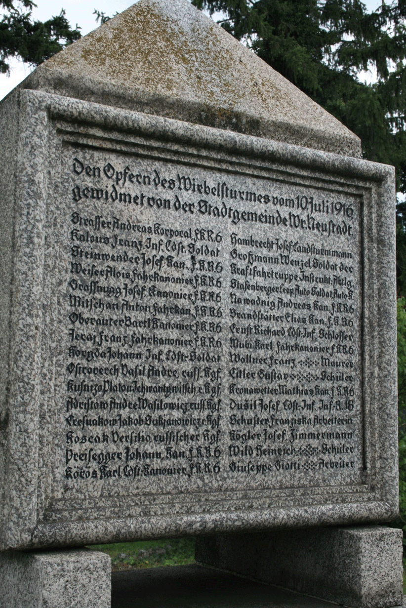
Figure 7Memorial in the cemetery of Wiener Neustadt, erected above the common grave of 32 of the tornado victims. Text: Den Opfern des Wirbelsturmes vom 10. Juli 1916 gewidmet von der Stadtgemeinde Wr. Neustadt [Namens- und Berufsliste] – Translation: “Dedicated to the victims of the whirlwind of 10 July 1916 by the City of Wiener Neustadt [list of names and affiliations]. Photo: Alois M. Holzer.
By applying a forensic analysis, an error in the originally reported number of fatalities was revealed. All primary historical sources quote a number of 32 fatalities, as do the official police list published on 15 July 1916 (WNN, 1916) and the remembrance stone in the cemetery (Fig. 7). The police list also includes people who were severely injured, some of whom later appeared on the remembrance stone in the cemetery. It is plausible that these persons died soon after the event due to their severe injuries and were buried together with most of the other victims in a common grave in the cemetery of Wiener Neustadt. However, a side note within one of the eyewitness reports (Bauer, 1916) mentions that a few victims were buried in neighboring villages. These names originally appeared on the police list but are missing on the memorial stone. While unnamed persons on both lists could further increase the true number of fatalities, no fatalities outside of Wiener Neustadt are known. The additional information from the eyewitness account brings the total number of fatalities to at least 34.
180 single damage sources were found. This number was about 1 order of magnitude higher than originally expected. Therefore the authors stress that it can be rewarding to search historical archives for damage photos and reports of possible tornado and severe storm events.
The authors of the study found that the rating on the Fujita Scale into half-steps above F3 would have resulted in an over-confidence of the rating precision, and therefore refraining from doing so. It should be left open if such precision can be achieved in other cases. In some cases, the assignment of appropriate DIs was difficult, not because of a lack of information, but due to a lack of selectable DIs. Therefore, a wider range of DIs would be desirable both for buildings and vegetation. Regarding vegetation, Fujita (pages 33 and 283, Fujita and Merriam, 1992) used damage signatures in cornfields and in forests alone (without building references) for classifications up to F5. Fujita documented different stages of vegetation damage on a series of photos for the whole range of the F-scale. Additional damage indicators for vegetation were recently introduced by Hubrig (2015) and can be used in future damage assessment. These DIs for mainly wooden plants were not yet available for this study.
Still, consistent damage rating is very difficult on a global scale. Outside the United States, damage resulting from the same wind speed can be distinctly different because of strongly different building practices and building styles. Wood-frame houses are a primary indicator for severe tornadoes in North America, where the Fujita Scale originated, while other building styles are prevalent in large parts of Europe. At the time of completion of this paper, an initiative arose to harmonize tornado intensity ratings worldwide. An international working group formed with the intent to assess the current status of tornado ratings globally and eventually reach a consensus on an International Fujita Scale (IF-scale), as proposed earlier by the ESSL (Holzer and Groenemeijer, 2015). Harmonization of tornado ratings has a wide range of implications, from the engineering sector to climatology, and will facilitate future tornado research.
Such a harmonized tornado scale can only be a first step towards a more reliable estimation of tornado wind speeds, as it still heavily relies on expert estimates, especially in the upper range of the intensity scale. More research is desirable in the form of experiments, calculations and observations, to support more precise estimates in the case of a given damage.
It has proven useful to document a historical tornado case in great detail also for the purpose of civil protection and citizen science. The given outcome served as a scenario for civil protection exercises in the town of Wiener Neustadt. On the 100th anniversary of the tornado, an exhibition was opened in the City Museum of Wiener Neustadt that became one of the most-visited exhibitions of the year. In addition, guided tours along the damage path were organized by ESSL and raised significant public interest. Historical damage photograph posters were presented and explained on site of the original damage.
The methodology outlined in this study can be exemplary for the analyses of similar cases by closely following these steps in chronological order:
-
retrieval of historical sources and their preparation
-
geo-referencing of source information
-
application of the DI–DoD approach to the historical material
-
aggregation of singular data points into damaged objects
-
data mapping.
By successfully applying this repeatable forensic method, the earlier questions raised in Sect. 1 can be answered:
- a.
A surprisingly high number of both damage photographs and damage reports was found in historical archives.
- b.
The tornado after 100 years could be rated as F4 on the Fujita Scale within the urban area of Wiener Neustadt, where a high number of damage points allowed mapping damages for a majority of the buildings struck.
- c.
A coherent meteorological picture of the entire event could not be drawn because of lack of storm-scale data.
Along uninhabited parts of the damage track, open questions remain, especially regarding the formation of the main tornado that finally struck the town of Wiener Neustadt. The main tornado that struck Wiener Neustadt formed out of two predecessor tornadoes that approached each other in an angle of about 70∘, representing a rare case of complex tornado genesis. The total damage track length was 20 km, including the western predecessor tornado. The maximum tornado width was 600 m respective to the damage and 1 km according to eyewitness estimates. The number of fatalities was found to be at least 34, rather than the 32 persons reported in the original sources.
To facilitate similar analyses in the future, more DIs for buildings and for vegetation are desirable. The authors wish to support an international working group with the goal to reach a consensus on an International Fujita Scale (IF-scale). Concluding, we would like to encourage others to research strong historical tornado events.
The supplement contains all photo analyses data related to this study in a spreadsheet distributed under the Creative Commons Attribution 4.0 License together with this paper.
The supplement related to this article is available online at: https://doi.org/10.5194/nhess-18-1555-2018-supplement.
The authors declare that they have no conflict of interest.
We thank Mathias Stampfl for the initiative for this project, his
practical effort during the project work, for the essential help in the
accomplishment of the guided city tours along the historical tornado track
and other voluntary work that was crucial for the success of this
undertaking. We acknowledge support from Pieter Groenemeijer and
Georg Pistotnik, who provided input to the project report.
Charles A. Doswell III provided us with independent ratings for selected
damage photographs, offering an experienced perspective on some of the
historical but crucial damage sites. We thank Otto Svabik, now retired from
ZAMG, for the provision of the original historical weather observations from
Austrian mountain observatories. We thank the ESSL internal and external
reviewers of this paper for their helpful feedback, especially
Christopher Castellano. Without the large number of people who provided
valuable tips, hidden information or other support to help us achieve our
goals, this project would not have been feasible. This work was supported by
the City of Wiener Neustadt under the project title “TORNeustadt”. The
following archives provided us with original sources, which we are thankful
for: Industrieviertelmuseum, Stadtarchiv Wiener Neustadt, Stadtmuseum Wiener
Neustadt, Österreichisches Staats- und Kriegsarchiv Wien, Freiwillige
Feuerwehr Wiener Neustadt and several private persons.
Edited by: Vassiliki Kotroni
Reviewed by: Greg
Kopp and two anonymous referees
Antonescu, B., Schultz, D. M., Lomas, F., and Kühne, T.: Tornadoes in Europe: Synthesis of Observational Datasets, Mon. Weather Rev., 144, 2445–2480, https://doi.org/10.1175/MWR-D-15-0298.1, 2016.
Antonescu, B., Schultz, D. M., Holzer, A. M., and Groenemeijer, P.: Tornadoes in Europe: An underestimated threat, B. Am. Meteorol. Soc., 98, 713–728, https://doi.org/10.1175/BAMS-D-16-0171.1, 2017.
Antonescu, B., Fairman Jr., J. G., and Schultz, D. M.: What's the Worst That Could Happen? Re-examining the 24–25 June 1967 Tornado Outbreak Over Western Europe, Weather Clim. Soc., 10, 323–340, https://doi.org/10.1175/WCAS-D-17-0076.1, 2018.
Bauer, K.: Augenzeugenbericht Karl Bauer Lichtenwörth, Stadtarchiv Wiener Neustadt, 1916.
Brázdil, R., Chromá, K., Dobrovolný, P., and Cernoch, Z.: The tornado history of the Czech Lands, AD 1119–2010, Atmos. Res., 118, 193–204, https://doi.org/10.1016/j.atmosres.2012.06.019, 2012.
Brown, P. R. and Rowe, M. W.: Tornadoes in Great Britain and Ireland to 1960: Part 1: Years AD 1054–1800, Int. J. Meteor., 37, 145–154, 2012.
Brown, P. R., Meaden, T. G., and Rowe, M. W.: Tornadoes inGreat Britain and Ireland to 1960: Part 2: Years AD 1801–1850, Int. J. Meteor., 38, 17–25, 2013a.
Brown, P. R., Meaden, T. G., and Rowe, M. W.: Tornadoes in Great Britain and Ireland to 1960: Part 3: Years AD 1851–1875, Int. J. Meteor., 38, 68–77, 2013b.
Dessens, J. and Snow, J. T.: Tornadoes in France, Weather Forecast., 4, 110–132, https://doi.org/10.1175/1520-0434(1989)004<0110:TIF>2.0.CO;2, 1989.
Dörr, J. N.: Die Windhose von Wiener Neustadt am 10. Juli 1916, Meteorol. Z. 34, 1–14, 1917.
Doswell, C. A. III, Brooks H. E., and Dotzek, N.: On the implementation of the enhanced Fujita scale in the USA, Atmos. Res., 93, 554–563, 2008.
Dotzek, N., Groenemeijer, P., Feuerstein, B., and Holzer, A. M.: Overview of ESSL's severe convective storms research using the European Severe Weather Database ESWD, Atmos. Res., 93, 575–586, 2009.
EF-Scale document: A Recommendation for an ENHANCED FUJITA SCALE (EF-Scale), available at: http://www.depts.ttu.edu/nwi/Pubs/FScale/EFScale.pdf (last access: 9 December 2016), 2006.
Feuerstein, B., Groenemeijer, P., Dirksen, E., Hubrig, M., Holzer, A. M., and Dotzek, N.: Towards an improved wind speed scale and damage description adapted for Central Europe, Atmos. Res., 100, 547–564, 2011.
Fujita, T. T.: Proposed characterization of tornadoes and hurricanes by area and intensity, SMRP research paper, University of Chicago, vol. 91, 42 pp., 1971.
Fujita, T. T. and Merriam C. E.: [Memoirs of an Effort to Unlock] THE MYSTERY OF SEVERE STORMS [During the 50 Years, 1942–1992], Wind Research Laboratory Research Paper 239, Dept. of Geophysical Sciences, University of Chicago, Chicago, IL, 298 pp., 1992.
Gayà, M.: The 1886 tornado of Madrid, Atmos. Res., 83, 201–210, https://doi.org/10.1016/j.atmosres.2005.10.017, 2007.
Groenemeijer, P. and Kühne, T.: A Climatology of Tornadoes in Europe: Results from the European Severe Weather Database, Mon. Weather Rev., 142, 4775–4790, https://doi.org/10.1175/MWR-D-14-00107.1, 2014.
Groenemeijer, P., Púčik, T., Holzer, A. M., Antonescu, B., Riemann-Campe, K., Schultz, D. M., Kühne, T., Feuerstein, B., Brooks, H. E., Doswell III, C. A., Koppert, H.-J., and Sausen, R.: Severe Convective Storms in Europe: 10 Years of Research at the European Severe Storms Laboratory, B. Am. Meteorol. Soc., 98, 2641–2651, https://doi.org/10.1175/BAMS-D-16-0067.1, 2017.
Holzer, A. M.: Tornado climatology of Austria, Atmos. Res., 56, 203–211, https://doi.org/10.1016/S0169-8095(00)00073-9, 2001.
Holzer, A. M. and Groenemeijer, P.: Towards an International Fujita-Scale (IF-Scale), ESSLs Current Tornado and Storm Damage Rating Practice, available at: https://www.essl.org/cms/wp-content/uploads/20150902-Towards-an-International-Fujita-Scale-ESSL-rating-practice.pdf, 2015.
Hubrig, M.: EF – Scale enlargement for wooden plants, European Conference on Severe Storms 2015, ECSS2015-146, available at: http://meetingorganizer.copernicus.org/ECSS2015/ECSS2015-146.pdf (Table: https://www.essl.org/cms/wp-content/uploads/ECSS-2015_Poster-hub-final.pdf) (last access: 26 May 2018), 2015.
Johns, R. H., Burgess, D. W., Doswell III, C. A., Gilmore, M. S., Hart, J. A., and Piltz, S. F.: The 1925 TriState tornado damage path and associated storm system, Electronic J. Severe Storms Meteor., 8, 1–33, 2013.
Letzmann, J. P.: Richtlinien zur Erforschung von Tromben, Tornados, Wasserhosen und Kleintromben, Anlage XI, 91–110, September 1937, in: Klimatologische Kommission, Protokolle der Tagung in Salzburg, edited by: Météorologique Internationale, Secretariat de l'Organisation, IMO Publ. Nr. 38, 149 pp., 1939.
ÖBL: Österreichisches Biographisches Lexikon und biographische Dokumentation, Verlag der Österreichischen Akademie der Wissenschaften, vol. 10, p. 284, 1992.
Snitkovskii, A. I.: Tornadoes in the USSR, Meteor. Gidrol., 9, 12–25, 1987 (in Russian).
Taszarek, M. and Gromadzki, J.: Deadly tornadoes in Poland from 1820 to 2015, Mon. Weather Rev., 145, 1221–1243, https://doi.org/10.1175/MWR-D-16-0146.1, 2017.
van der Schrier, G. and Groenland, R.: A reconstruction of 1 August 1674 thunderstorms over the Low Countries, Nat. Hazards Earth Syst. Sci., 17, 157–170, https://doi.org/10.5194/nhess-17-157-2017, 2017.
WNN: Eine verheerende Windhose über Wiener Neustadt am 10. Juli 1916, Sonderabdruck der Wiener Neustädter Nachrichten, special issue of a local newspaper on the occasion of the tornado, 1916.